
Do you know how to read a map?
In today's world, GPS and satellite navigation are reliable as all get-out, but even the most advanced GPS devices use base maps as the viewable interface. But what do you do if you GPS stops working?
I personally prefer planning a route on a map, but then transfer that route to a device, tablet to be shown in Gaia or "other" navigation system. In my prior life, I was a navigator on ocean going vessels, and route planning was a part of our everyday lives, prior to that, I taught map and compass skills to college kids, so offroad/backroad navigation comes natural... but not to everyone.
There's a lot of information on a basic topo map that can help you "stay found" and pick a route, for instance:
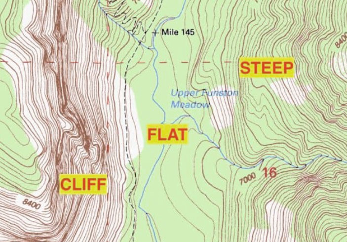
- Contour lines: Know the scale and interval of each line so you can gauge the steepness of the ridge that your thinking of traversing. Contour lines will tell you if you're ascending or descending along a route, or potentially crossing over a saddle or valley. Get to know these features, and what you see on your display will make much more sense. Typically a topo will tell you that contour lines are in XXX intervals, but you can also do the math using elevation points along those lines.

- Elevation points: Along with contour lines, topo maps often include specific elevation points known as spot elevations. These points indicate the exact elevation at a particular location, providing precise height measurements in relation to sea level. Spot elevations are usually marked with numbers on the map, allowing you to identify significant landmarks and plan your approach accordingly. Sometimes these are in feet and sometimes that may be in meters.

- Symbols and Icons: Topo maps feature an array of symbols and icons that represent various physical features such as roads, rivers, lakes, forests, and man-made structures. Get to know them and you'll have more reference points to determine where you are along your route.

Also, ask yourself "can I navigate my way out of here if my GPS stops working?". The answer should be yes and it never hurts to carry a few topo maps as backup... providing you know how to use it. Combine that with some compass skills, and you'll be dialed. There's something very "real" about laying out your topo on the hood of your rig and going over the day's plan and you might even discover some cool stuff to check out along the way.
I highly recommend picking up a topo map and sitting down to familiarize yourself with every aspect of what they have to offer. It might be handy someday.